Pupu Hydro Walkway
DOC track · Nelson/Tasman
Pupu Hydro Walkway is a 5.4 km DOC walk in Nelson/Tasman with 231 m of climbing and a high point of 207 m.
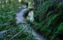
Retracing an old gold-mining water race, this short walk passes through forest of young beech and rimu to mature podocarps - it's good for children but be sure to supervise them.
Track stats
| Distance | 5.4 km |
|---|---|
| Time (DOC) | 1hr 50 min |
| Difficulty (DOC) | Easy |
| Track type | Walking Track |
| Elevation gain | 231 m |
| Elevation loss | 230 m |
| Highest point | 207 m |
| Lowest point | 58 m |
| Region | Nelson/Tasman |
| Start | -40.85578, 172.73842 |
| End | -40.85545, 172.73785 |
Distance, elevation and the profile are worked out by TrailTreks from DOC's track line and the LINZ 8 m elevation model, from the start marker on the map. Time and difficulty are DOC's.
Elevation profile
GPX file
Download the Pupu Hydro Walkway GPX file (DOC's full track line with elevations) for your GPS or mapping app.
Alerts and conditions
Check current alerts on DOC before you go: tracks close for slips, floods, fire risk and pest control. The DOC page also has access, facilities and safety information.
Nearby DOC tracks
- Te Waikoropupū Springs Walk (2.8 km away)
- Anatoki and Historic Kill Devil Pack Tracks (4.6 km away)
- Parapara Peak (5.3 km away)
- Paines Ford Tramline Track (6.8 km away)
- Rawhiti Cave Track (10.2 km away)
Plan it offline in TrailTreks
Plan Pupu Hydro Walkway in the free TrailTreks: NZ Topo Maps app: LINZ topo maps that work with no signal, DOC huts, tracks and alerts, and mountain weather.