Routeburn Track: Key Summit Track
DOC track · Fiordland
Routeburn Track: Key Summit Track is a 4.8 km Great Walk in Fiordland with 308 m of climbing and a high point of 942 m.
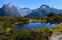
Enjoy panoramic views over mountains and alpine lakes on this half-day walk off Milford Road on the Routeburn Track - it's suitable families with children.
Track stats
| Distance | 4.8 km |
|---|---|
| Time (DOC) | 3 hr |
| Difficulty (DOC) | Intermediate |
| Track type | Great Walk |
| Elevation gain | 308 m |
| Elevation loss | 224 m |
| Highest point | 942 m |
| Lowest point | 535 m |
| Region | Fiordland |
| Start | -44.82511, 168.11764 |
| End | -44.81166, 168.13005 |
Distance, elevation and the profile are worked out by TrailTreks from DOC's track line and the LINZ 8 m elevation model, from the start marker on the map. Time and difficulty are DOC's.
Elevation profile
Campsites near the track
- Greenstone Saddle Campsite (1.3 km from the track)
GPX file
Download the Routeburn Track: Key Summit Track GPX file (DOC's full track line with elevations) for your GPS or mapping app.
Alerts and conditions
Check current alerts on DOC before you go: tracks close for slips, floods, fire risk and pest control. The DOC page also has access, facilities and safety information.
Nearby DOC tracks
- Routeburn Track: Lake Howden Track (0.0 km away)
- Lake Marian Falls Track (2.2 km away)
- Lake Marian Track (2.2 km away)
- Falls Creek Route (3.1 km away)
- Pass Creek Track (3.5 km away)
Plan it offline in TrailTreks
Plan Routeburn Track: Key Summit Track in the free TrailTreks: NZ Topo Maps app: LINZ topo maps that work with no signal, DOC huts, tracks and alerts, and mountain weather.